Tuesday, November 18, 2008

THE DIVIDE CUT November 15, 2008

Returning last night from Frankie J's Restaurant and the Grocery, it began to rain. While Debbie did the laundry, it increased and continued all night. The rain on the roof top sounded like rain on a tent but our sides were not wet nylon! It felt good to get in our warm bed and snuggle.


All to soon the alarm rang. We quickly got dressed for another great day. Did someone forget to turn on the sun? The air outside and in was thick enough to cut and it was misting outside. When it rains, the water drops periodically clean off the window. When it mists, we have to wipe them frequently. So as we continued down the Yellow Creek to the Tenn-Tom Waterway and for the first 3 hours from 7-10 we wiped windows inside and out. Tom even tried a fan on the inside of the window to keep it from fogging up! It did not work!


The Tenn-Tom connects the Tennessee River at Pickwick Lake with the Tombigbee River at Demopholis AL. Below Demopolis it is called the Black Warrior-Tombigbee Waterway. Construction on the Waterway began in 1972 but was not completed until June of 1985. More earth was moved in this project than for the Panama Canal! It shortened the trip by as much as 720 miles. A vessel going from Pensacola FL to Chattanooga TN would travel 771 miles rather than 1,541 via the Mississippi River .


The Waterway runs downhill 341 feet over 450 miles from Pickwick Lake to Mobile. We are back on green for RBD and red for LBD. The Waterway is divided into three sections. Today we entered the 27 mile "DIVIDE CUT" which ends at mile 441.9 and the Whitten Lock, our first lock of the day. It connects the Tennessee and Tombigbee River basins and is 280 feet wide and 12 feet deep. Along this stretch we passed one barge 2 x 2 and one pleasure boat passed us! Also in the Divide Cut we passed into the state of Mississippi .


The next 52 miles is the "CANAL SECTION", which consists of dams and pools. It contains 6 locks and dams. We will cover 20 miles of the Canal Section today and the rest tomorrow. The Divide Cut is separated from the Canal Section by the Whitten Lock and Dam (above). It is the third highest lock east of the Mississippi and the fourth highest in the nation. The drop is 84 feet.


It took us an hour to clear Whitten Lock. We waited about twenty minutes for the lock to filled, went in, tied up and then slowly descended as the water was let out. Looking up a bollard really gives you a feeling of the depth inside.


The final lock of the day was Rankin, also with a 30 foot drop.


Compare the depth of Whitten (picture before) with Rankin (below).


Our home for the night is Midway Marina, four miles further down the river and the halfway point on the Canal Section. We finish the day at 56 miles including 3 locks in 8 1/2 hours. After gassing up (we are getting almost 6 mpg with both engines at 3,000 rpms), we borrowed the loaner car and visited Walmart for an extension cord to put a light in our fresh water pontoon. Dinner at Wendy's. It is predicted to be 20 degrees tonight? We are glad to be on the downhill river flowing into the warm weather gulf!


Monday, November 17, 2008

PICKWICK LAKE November 14, 2008

Outside our windows the trees were covered with fog. Not dense but wet. As Debbie wiped down the windows, both sides, Tom started the motors. He started each again. Neither motor would start! We had plenty of gas but they just wouldn't turn over. Here we are out in the middle of Tenneesse with no motors with the trailer camp which looks unoccupied our nearest neighbors a mile up river. Now any wise person would have a good solution. Debbie made breakfast and Tom took the cover off the motor and tinkered around. After a long while it started. When asked what was wrong, Tom said, "I have no idea but it works no

After that tiring experience, Tom went to the office (above). Note the GPS and autopilot along side the maps on the first mate's side. When it is humid, she spend lots of time wiping the inside and outside of the windows while Tom catches a nap!


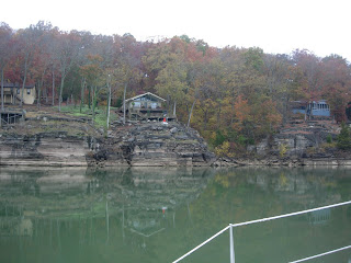
It is not a dream that the along the shore there are often high bluffs. The houses had great views.


You might call this one a high cliff house.


Note the little shed with the chimney half way up the hill. There are extensive stairs to climb and the hill has been planted, probably with grass and covered with a sheet. We speculated that this was either a get away one room shack, a river halfway house or the servants quarters for a larger spread up the hill.


We traveled with two motors running and made at least 6 mph. This is what we usually make with one motor but today the water is being let out of the Pickwick Dam giving us a current to slow us down.
Pickwick Lock is our second one on the second half of our trip and our sixteenth lock of the trip. The newer locks have two chambers and we, a single small boat, are sent to the larger one. We feel very small during the 53 foot drop. The prior lock on the other side of Kentucky Lake had a 57 foot drop. All newer locks also have bollards. Debbie has the line wrapped around the bollard with one end attached to the cleat and the other under the cleat end and held firmly by both hands. If she lets go, the boat will be free and can bounce off other boats or lock walls.


After the lock we entered Pickwick Lake.


A few miles along is the turnoff for Yellow River. After 8 hours and 46 miles on the river, we arrive about 3 p.m. at Grand Harbor Marina. Friends further down the River stayed here and received a 10% discount as members of US Boat. We take advantage of this, gas up, get a well deserved shower (after 5 days with none), go out to dinner and grocery shop.


The real estate near our marina will tell you something about how classy this marina is. The manager is very helpful. We keep four other transient boats company tonight.


Friday, November 14, 2008

TENNESSEE COUNTRY November 13, 2007

We awoke at first light and snuck out of Cuba Landing. "Snuck" means we drove very slowly hoping not to go aground. We did not but the bow anchor was stuck in some pretty sticky mud and Tom had to help yank it up.

The forecast was for occasional showers in the AM and sun later. Early yesterday was the day that we moved from Kentucky to Tennessee. Today we could notice the difference. The river has narrowed down and we see cliffs on at least one side. There are clusters of houses along the shore but we don't see any residents. Perhaps they have moved to warmer weather.


Fall leaves continue but are not as bright and some of the trees have lost their leaves. Above is a side stream. The water looks shallow. We will have to be careful picking tonight's spot.


We only pass three barges today but see equipment digging up sand and loading it on barges. There are few bridges and many unpopulated areas. During the morning the river looked like the picture below.


The clouds are above not in the river but the mirror water reflects them. When there is no wind or current (from water being released down river to make hydroelectric power), we make 6 mph with one engine.


Afternoon arrives and so does the sun.


Since there is not much traffic and driving is easy, we enjoy the scenery. Here is a house or two with a great view


Another thing we notice is that our verizon's service is spotty. That includes internet and phone. So if you cannot reach us or do not see our blog, we are okay.


As we get further down the river we start seeing banks covered with rocks to keep down erosion and houses on stilts. These steps to the water are about two stories high.


During the afternoon we see many trailers along the banks. Some of the parks only have a few scattered along the bank with many open lots. This is a sure signal to head south along with the trailer crowd. We have two anchorages picked out as there are few marinas in this area. The first one, Indian Creek, we find is adjacent to a trailer park. We decide to go a mile further to Swallow Bluff Island. It meets our expectations and we motor slowly behind the Island. Tom points out three very tiny deer nibbling grass on the bank. They are even smaller than the key deer.


We are off the river early 2:45 p.m. We do not have time to cover 20 more miles to the next anchorage (3 hours) before dark at 5 p.m. At the end of Swallow Bluff Island is another tiny nameless island. We drop bow and stern anchors in time to have a rice-vegetable-chicken casserole and salad as we enjoy the sunset.

Wednesday, November 12, 2008

RAIN and MORE RAIN November 12, 2008

We awoke after 6 a.m. and found our boat surrounded by autumn trees. About 5 a.m. the rain pattered on our ceiling but lightened up when we pulled the anchors.


Catrina was on the River by 7 a.m. We found the 3 W's: Wind, Waves and Wet. With the same rpm's we got 4 mph rather than 6 mph. It was downright uncomfortable outside. We closed down the cockpit and moved into the settee.


Tom connected the GPS and autopilot inside so each could be used from the settee. Here is Debbie running the boat as she looks out the front window. The only feature missing was the depth finder.


In front of Debbie is a set of Corp of Engineers Charts lent to us by Wendy. They show every marker and curve on the river all the way to Mobile. We can look up distances, marinas or overnight mooring areas.


Above is part of one page that shows a railroad bridge with one section removed. The blue area is water. The lower bank show a finger of land (in grey) come out into the river. The diamonds are red and green markers indicating the channel. The straight line is the recommended sailing course. The upside down dashed lines are deeper channels to areas at the sides. The boats at the sides are mooring spots. Now let's look at the bridge.


One thing that Tom missed when he piloted the boat from inside was a seat with a back. Inspiration hit and he found a good use for his crutch!


Late in the afternoon the rain stopped. We noticed the leaves again. Before we were concerned with the rain, fog and poor visibility. We were very concerned about the barges and not knowing they were there until a few hundred feet away. All day only two barges passed us. The River had frequent curves and a narrower width with a smaller deep channel.


About 4 p.m. we pulled off the river at Cuba Landing. Water was low in the entrance channel and again Tom moved very slowly to the gas dock for a fill up and pump out. We decided to take advantage of the pool on the way in. Below is a picture of the route around the edge to the marina. Just picture our boat just behind the white/red marker. That is where we spent the night as the rain fell gently on the roof.


ON THE RIVER - ER - KENTUCKY LAKE November 12, 2008


While Carol and Debbie fetched 5 days of drinking water and straightened up the boat, the fearless three (Tom, Glenn and Wendy) resinstalled the motor and moved the dingy motor back to its original home. Yes, you do have to drop the motor from the cockpit into the pontoon and secure it to the mount. But you also have to hook up the raising line and gear and throttle cables.


By Noon our friends waved goodbye and we were off. Captain Tom took the wheel finding a way to keep his operated knee up. Debbie kept an eye on his eyes to make sure they were open!


We crossed the Lake from the west side to the east as two barges moved south or down river. During the afternoon we only saw about 7 barges total and all were headed the opposite direction. We are traveling south but are going up stream. Because of Kentucky Dam and Lock at the entrance to the lake, we are in "pool" - no current but we can have wind and waves. It was a good refresher lesson to pass barges on the wide part of the river with no current. Also we remembered that going up stream meant that our left side would be RDB - Right Descending Bank - and the left markers would be green.

Not only do we wish to travel to warmer temperatures (it was under 40 this morning) but we can enjoy fall in another area than palm trees and sand. The leaves along the shores are in full color and the channel usually goes adjacent to the east side of the lake.


Before we know it, four hours have passed and the sun is setting over the west shore. This is the view out our back cockpit door. We will have to get up early if we plan to make many miles during these "short" days.


The sunset is beautiful as we hurry to find a protected spot off the barge route to drop anchor.


We decide to go a couple miles further to Fort Heiman Cove RDB (west shore). We have been traveling at 6 mph. In just 20 minutes it is pitch dark. The clouds are pretty in a sunset but they hide the moon!


As we enter Fort Heiman Cove at mile 62.6 RDB, the last rays leave us. Thirty one miles today. The cove is behind the right bank and is deep and a couple hundred yards wide at the bottom. Tom crept Catrina along keeping a close eye on the depth finder. Debbie sat on the bow ready to drop anchor. The depth was about 15 feet when Tom flashed the light relaying the drop anchor command. We have been traveling with all windows closed to preserve heat so we improvised and found a non-verbal command.

You may not be aware but Tom is addicted to TV so we double moored. Debbie put out 150 feet of anchor bow anchor line. When we were firmly grounded, Tom shut down the motors and dropped the stern anchor. Then Debbie pulled in some of the bow anchor line so that Catrina was in the middle of the two anchors. If we removed the slack, it would hold the boat in one position and we would not slip off the satellite signal!

Debbie put the leftover fajita mexican take home into a salad, added salsa and sour cream and a side of baked beans for a quick and easy 5 p.m. TV supper. It has been a full first day back on the River!

CATRINA AT LAST November 11, 2008

Dr. Mark discharged Patient Tom with instructions not to fall OVERBOARD! Carol and Glenn loaded up their van with all our stuff (as much as we took off October 12) and hauled us to Kentucky Lake. We cannot thank them enough for such good delivery service, friendship and wheeled-vehicle storage!

On the way we stopped and picked up the repaired motor. Wendy and Joan had referred and taken us to this marina, the best in the their area, and they were able to repair the damage (versus sell us a new motor). Glenn and Tom "carted" the motor to Catrina while Carol and Debbie unloaded the rest of the van. Then it was off to Wendy and Joan's, a visit to our favorite mexican restaurant in Benton (they also have a taco bell), grocery shopping at Wally World (of course) and home to bed. After over a month it was wonderful to sleep in our own bed with the water gently rocking us to sleep!

Thursday, November 6, 2008

SURGERY SUCCESSFUL November 6, 2008

Tom's Tuesday surgery went well with Dr. Mark finding more damage than the MRI showed. He was able to reach it and Tom should be good for a couple more years! Today he is almost off pain medication and can take his first shower! He can bear weight but should keep his knee up to keep swelling down.

Post Op appointment is Monday 10/10 and we anticipate getting the okay to return to Catrina.
We cannot thank the Mark (Son) family enough for our two week visit and excellent referal.