Tuesday, February 10, 2009

EVERGLADES February 9, 2009


The moon was just setting before the sun got up. We took one look and decided it was too early to get up yet. After all, we are retired!
Mid morning as we left Catrina in Tigger to explore the everglades, we looked back. We discovered that many open waterways from our home for the night.

Water, Snack Bars, Bug and Sun Cream, Camera, and Apples - Oh, yes, Hats and Rain Gear, and we are off. We had selected a circular route along narrow canals for our morning adventure. Mangroves were everywhere. We had read that hardwoods were in the Everglades but we did not find any.
The mangroves on Little Shark River LSR grow out and up. They are not short and could be called trees!
The tide was flowing out and the many mangrove roots showed. Roots were caked with mud. At Low Tide, this group of Mangrove Roots look like a sci-fi back drop.

Part of our trip took us to Ponce de Leon Bay which opens on to the Gulf. The trees along the Bay were dead and we wonder if a hurricane has passed a number of years ago.

We arrived back at Catrina to find the tide was pulling her in the opposite direction. Our two anchors had dug in and with Debbie cleating one line on the wrong end, we had a major job pulling them up. Finally after many words and lots of muscle work, the anchors were up and we moved Catrina just off the entrance to the LSR. That would subtract 10 miles from our trip tomorrow.
Tom added side lines in addition to the Bow and Stern Anchors. The Stern picture shows the two lines to the banks. We hope this will stabilize our satellite contact.

Tom also attached the two traveler cam cleats which has ripped out a few days ago when Debbie back winded the main. A big puff lifted her into the air, removing both cleats and depositing her on her back on the transom. The traveler allows the angle of the boom to be adjusted windward or leeward. Debbie was holding it windward to trap more air and give us forward momentum.

After lunch on Catrina, we were off in Tigger up the LSR. We ran all the way to Oyster Bay, which is on the Wilderness Trail (a boat/canoe path through the Everglades from Everglade City to Flamingo). We bounced quickly along on the waves being kicked up by the wind on this wider section of LSR.
On the way home we picked a more gentle speed and side canals. We stopped for snacks up a narrow route between the mangroves. It was close to high tide and we were right up next to the mangrove roots.

We found an entrance to this secret spot where no one passing could see us easily.

The mangroves formed a canapé over our heads

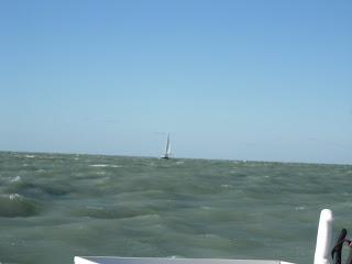
We ran down to the entrance of LSR and four boots were already in residence. A black Cat Boat from Ontario was headed north from the Keys. The Gemini 150 MC also was traveling north and had dropped anchor right in the middle of the River. He was from Ohio - Lake Erie.

Back home we treated ourselves to showers. Tom tried a little fishing until the gnats got him and Debbie made the dinner of fresh Tomatoes and Onions, Carrots, Tuna Salad and Baked Beans.

LITTLE SHARK RIVER February 8, 2009


The Alarm rang at 6:45 and we were off by 7 a.m. Tom headed Catrina for the 951 Bridge and Debbie documented the sunrise (above). At the advice of Loopers Sarah and Ted who winter at Marco Island, we departed the city by the inland south route up the Marco River. This would eliminate having to go out so far into the Gulf around Cape Romano Shoal.

The Marco River is very scenic but we may have made a major error in selecting this route. First we were sailing directly into the sun with very poor visibility. We left at mean low tide. Later we confirmed that we were at LOW low tide. This happens each year in January and February. We saw a lot more of the river bottom than we anticipated.

Please look closely at the mud flat and note the tracks across it. They are not ours but were made by other boats rubbing their bottoms!
We crept along watching both of our depth finders closely and our charts. Did I mention this was the BIG Marco River not the Little Marco River, if there is one. We passed under the 92 Bridge, 2/3 of the way to the Gulf. Next was Goodland and the patriotic Old Marco Restaurant and Trailer Park. We entered Coon Key Pass. Our depth finder was beeping which indicates a 4 foot or less depth. We foraged ahead at barely one mile and hour.

When we pass Coon Key Island (above) and then Coon Key Light, we enter Gullivan Bay which is adjacent to the Gulf of Mexico where depths should be 5 to 7 feet.

After studying the Charts we head up the north side of Coon Key. So far we have not seen one Coon. The Depth Finders move from 4 to 3 to 2 to 1.5 and we are pushing sand with our propellers. We backed up and tried another route. Same story. Maybe we picked the wrong side of the island. We tried the other side and the front depth finder registers zero and then nothing. Since it is in the bow, we either coated the bottom with thick sand or we are aground. Tom was able to back Catrina up so we weren’t aground. Tom was not ready to accept defeat and went back to the north Coon Key shore. This time he went up the left side and again the remaining rear depth (fish) finder showed 1.5 feet. Please remember our draft is about 3 feet deep. Maybe the depth finder lied or wasn’t accurate at low numbers. We continued slowly with both motors and after what seemed a very long time, the depths began to slowly got bigger 2 - 3 - 4 . Whew! We could see Coon Key Light in the distance. If the bottom was anything but sand, we would be buying new propellers and maybe motors, fins and rudders.

We passed Coon Key Light (that is Marco Island on either side of the light) and entered Gullivan Bay about 10 a.m. In three hours we had gone only 10 to 12 miles. But we could look back at Coon Key Island and know we had beaten nature!

Catrina is not quite as filled with instrumentation as an airplane but you be the judge.

Left of this picture are the primary Radio, Radar and Gear Throttles. The top row holds the GPS, the main Eyes of the Craft. Next down on the left is the Fish Finder which contains the Stern Depth Finder. The Compass sits in the middle. Under the Fish Finder is our second Radio and Air Horn. The bottom instruments are Speed, Depth (bow), Wind (direction and speed) and Auto Pilot. On the adjacent side wall are Motor RPMs and a blow horn. Tom cleverly placed the GPS so that it could be turned to face the Settee inside. The Auto Pilot has a Controller which can be used in the settee or front deck. On the left an indoor/outdoor Thermometer is mounted next to the Controller holder and on the Nav Station.

From Coon Key Light to Little Shark River is about 35 to 40 miles. Debbie is not sure the inner route saved us any mileage but it was scenic and exciting!

Little Shark River was reached about 4:30 after slow and fast sailing, spinnaker and no spinnaker sailing and some motor assisted sailing. A few motor boats, a fishing boat, a crabber and one beautiful blue trimmed sailboat passed us.

Can you pick out the entrance of Little Shark River? I’ll give you a hint. It is in the picture below!
We were not the first! Most of the boats you see will be leaving in the morning.


As we spent the next hour or more motoring up LSR, we saw many different sides of the everglades which we well explore tomorrow.

About 6 p.m. after 11 hours and about 50 miles on the water plus 10 in the everglades, we pulled off LSR in what we hoped with be a secluded spot for the night. We don’t have internet here but we do have satellite TV. Our nearest neighbor was down river a ways. The Moon was full and the night was so quiet we could hear all the everglade night sounds! This Debbie’s favorite night yet of this wonderful trip!

Saturday, February 7, 2009

MARCO ISLAND February 7, 2009

The Saturday dawned cloudy with a light wind. We were up by 7:30 and ready to fuel Catrina when the staff at Moss Marina arrived. We said good bye to our new friends Don and Kathy from Texas. They were going to sail with us but with a six foot draft on their 40 foot sailboat, they had to wait for the tide to rise. Catrina with 3 feet sailed right out into the Gulf.
Below is a picture of Flight, Kathy and Bob's Valiant 40.
In six hours we covered 35 miles to Marco Island. The sun came out and the wind varied from light to 19-20 mph. The wind direction changed from a broad reach to a tight reach (across the boat). In lay language, someone had to keep an eye on the wind and adjust the auto pilot or actually skipper Catrina.

However, the wind was in a great range for our spinnaker which we used frequently. But then the wind would get over 15 knots or the direction would change to a beat (toward the front) and the spinnaker would start wildly flapping. So we found ourselves continually putting up and taking down the spinnaker. If you were racing, this would be great practice and I am sure we needed practice but it was also work. We just wished to sit and look at our beautiful spinnaker!
We could see "Flight" in the distance behind us as we dropped sail and motored up Marco River. We dropped anchor farther up the River in a spot we had used last April where the River was wider and within dingy distance of a good restaurant! Flight anchored just behind us.

Tom was our chauffeur to Snook Inn for dinner. Our dingy fits two easily, is tight with three and underwater with four!


When we got to the Shook Inn, we hunted for steps but found none. Docks were built high above the water to accommodate boats. Finally we found some rocks that we could reach and climb up to the top! I guess guests did not usually arrive by dingy!

Conversation, drinks, fish sandwiches and salad bar were enjoyed by all. Tom escorted Kathy and Don to Flight by dingy and we all said good night. Hope to see you at Marathon - Boot Key!

Friday, February 6, 2009

FORT MYERS BEACH February 6, 2009

As we left Charlotte Bay, we passed a memorable home for two ospreys. One flew away!


The Charlotte Lighthouse on the point was closed in the late 60's and let run down. The locals decided to refurbish it to it's original design. Since it is such an unusual shape, Debbie just had to take a picture of it. When we passed it yesterday, we thought it was a residence!


Sailing south on a gentle sea and light winds, we saw a group of pelicans. In the background the Sanibelle Island Shoreline is covered with wall to wall condos and other rentals.


The pelicans took off and landed right next to a Crabber as he pulled up a trap!


Just south of Sanibelle Island is Fort Myers Beach. It took us a lot longer than we planned to go the 25 miles from Charlotte Bay to Fort Myers - 7 hours. A very Relaxed Day!


The picture below is of the Gulf side of Fort Myers Beach.


We motored into the bay and behind FMB. The north end of the Island is a white sand point and looked like a lovely place to enjoy nature. However, boats passed on all three sides and Highrises were on the fourth side!


Moss Marina is located a short distance south on the ICW just before the bridge from Fort Myers to FMB. We were given a slip right next to the Marina Office. The staff was very helpful in helping us tie up. While we were doing this, we looked up and there stood our friends Rose and Gary Oles. We first met them at Joliet, IL and crossed paths a few times on our way south to Crystal River.

While Tom was setting up our Satellite Disc, a Casino Transit Ship arrived at the end of our dock and unloaded more people than we could count!


After getting cleaned up (a warm Shower can be heaven), we went to their beautiful Carver named Rose's Pick.

Tom and Debbie went exploring around FMB near the Marina. It is good for Tom to walk some every day so we took advantage of this and had a very good dinner at Yucatan and then Raison Rum and Chocolate Sunday at the Yogurt Shoppe! A luxury our small Freezer can not hold.


After our stroll, Gary and Rose came to Catrina to visit. It was so good to get caught up. Boating people are a very good people. Thanks Rose and Gary for a fun evening

Thursday, February 5, 2009

BOCA GRANDE February 5, 2009

Thursday was a 3 S day. The wind was reduced in power from yesterday and the sailing was smooth. We covered 53 miles in nine hours of some of the nicest sailing. Tom worked on little projects and Debbie washed salt off the forward windows. The autopilot did most of the steering and we got a nice afternoon nap. We did not see another boat until we passed one motoring out of Charlotte Harbor.


Tom, Catrina's Favorite Navigator, found a route into Charlotte Harbor that saved us at least 2 miles. Debbie held her breath as we hugged the shore and watched the depth finder creep up. The shore waves chased us downwind. If we got to 3 feet the chances of us turning around in the narrow channel and heading back into the waves successfully was very small. The depth reached 5 feet which gave us a couple feet for our hulls to go up and down over the waves. Whew!


We moved up the north shore of Charlotte Harbor and into a small inlet. On the east bank was a golf course while large homes with large boats lined the west bank. About 500 feet up a narrow, curvy stream, the river widen and we found the Pink Elephant Pier on left side and many sailboats backed into the right bank. Up river was a very low bridge. We found a spot where we could fit between two boats and dropped our bow anchor, backed into the the bank, dropped our stern anchor and tightened up.


We jumped (just kidding) into our dingy and Tom paddled across the river to the Pink Elephant (a restaurant) Pier. On our hike around Boca Grande we found the town lived up to its name--a second golf course, large residences and hotels, beautiful parks and landscaping.


The grocery was three blocks from the dock and the gulf was five. To reach it, Tom passed through a hedge!


There were a number of real estate offices with the smallest house running over 700,000 and the largest we could find for 5 1/2 Million! Now you know why there were so many real estate businesses. Our favorite is below.


That's a Tarpon. They are very large fish!


We checked out a number of restaurants and decided they were looking for a more exclusive client. We returned to the Cream Colored Catamaran for tacos and tv.

Wednesday, February 4, 2009

CALADESI TO SANTA MARIA February 4, 2009

What a good night's sleep! Finally at 10 am we left our hideaway for the Inland Waterway. The wind was still howling but the sun was bright and the water was choppy with 14-16 mph winds. A Great Day!
At Clearwater we ventured out into the Gulf. I wasn't sure we would make it out because the waves were coming right at us and they were big! We turned south and enjoyed the waves, wind and speed. Here is a picture out our stern.


Since this is also a fishing trip, Tom made a fishing cleaning station which he attached to the stern railing.


Nobody was out on the water today. We did not see a single boat until almost 1 pm when Debbie sporatically saw four stacks above the waves. She called Tom out to look. It was decided it was the top of a freighter and it did not seem to be moving. As we approached the Tampa Shipping Channel a boat did emerge above the waves through our front window.


The drops on the glass are from waves but it is defiinitely a freighter.


As we drew closer, Debbie took a picture through the side window. Sorry, I bet you did not want to see our screened window!


The freighter was at anchor just outside the shippng channel. Because it was so big we could see it for miles as we rode up and down over the waves.

It is a lot of work putting sails up and down and adjusting lines in 15-24 mph winds. Whenever possible, we did it from inside. If we had to go outside, a life preserver was standard attire. The autopilot worked well until the waves go to four or five feet in height. At that point we stopped monitoring and took the wheel. Tonight we are saying "good job" with a shoulder/back massage for the other person. It is amazing how many muscles get used just staying upright much less steering on a very toss-ee-turv-ee boat!


At the northside of Santa Maria Island a black hulled sailboat appeared near shore. Tom was at the helm and he decided the other boat was racing us. As they moved farther off shore and we worked our way toward Longboat Key Bridge (Passage to ICW), we upheld the honor of the catamarans by passing in front of them. Poor Monohull!


About 50 miles and 7 hours later we called the bridgemaster at Longboat Key. He said he has been watching us as we headed into the wind and dropped sail. Tom had to start both motors to keep Catrina into the wind so Debbie could quickly go up on deck and lower the main. As promised, the bridgemaster raised the bridge just in time for us to pass through. It is not easy to stay in the narrow channel and zigzag waiting for a bridge to be raised. We gave him a big wave of "thank you"!


In route Debbie had called cousin Wally for Pete and Nancy's phone number. Wally and Helene were in a museum in New Orleans but came up with the number without being kicked out off the tour! Pete and Nancy couldn't join us for dinner but did give us a suggestion of a good spot to drop anchor and that is where we are tonight. Out our windows are sparkling house lights along the ICW and the water is gently rocking Catrina as the wind continues to whistle around us. We turned on our water heater and Oh Boy! did that shower feel good on our sore muscles!


pic 82