Sunday, October 12, 2008

32nd Day On Catrina October 12, 2008


The sun is just rising as we look around our "bed" for last night and find a quiet channel on the south side of Cuba Toehead. Tom takes down our make-shift mast light and pulls the anchor and we are headed south up the Tennessee River. This river is another backwards rivers that flows from south to north. The red markers are on the our right not left side.


Along the way we see a new type of dolphin. What's a dolphin? It is a very secure structure used by barges to tie up and looks like a large concrete drum. These are taller which allows for changing river levels.


Twenty two miles and we are at the Kentucky Lock and Dam. It is a very deep lock with a 57 foot lift. Tom calls the Lockmaster and keeps his fingers crossed that we will not have to wait hours. The Lockmaster says, "I'll get everything ready and you can drive right in!" Tom pushed the throttles full forward and we took off for the Lock in joyful surprise.


We drive in, pick a bollard, the lower gate closes and the water quickly fills the 58 foot well. We felt like royalty! We are so happy we chose the short route on the Tennessee (versus the Cumberland) and risked a long wait!


Kentucky Lake is one of the largest man-made bodies of water in the world covering 160,000 acres with 2,380 miles of shoreline. We will travel more than 240 miles on Kentucky Lake to the Tennessee-Tombigbee Waterway.


As we head up the lake and then move to the west coast but find it very shallow (3 feet). It is very important to be on the correct side of the markers. The barges travel along the east side of the lake but we are headed for mile Bear Creek at Mile 31 on the west coast. Sailboats dot the lake and motor boats roar by us. Neat, well kept cottages are built high above the water line.


Docks are sprinkled in the coves. We reach Bear Creek Cove and turn in to the Moors Marina and Resort, Catrina's home for the next couple weeks.


It is time for Tom and Debbie to get back to the real world (shutter). We need to take our truck-camper-boat to Florida. After 32 days, we have traveled about 600 miles in the great lakes, 627 miles on the Chicago, Illinois, Des Plaines, Mississippi, Ohio, and Tennessee Rivers. We have passed through, over or around 14 locks. We have made many good friends and shared many new experiences. When we return in November we will continue our blog for 634 miles on Rivers and 14 locks and then a trip across the Gulf to Crystal River.

Saturday, October 11, 2008

OHIO October 11, 2008


Upon leaving Little Diversion Canal at 8 a.m. we encountered barges. The whole way down the Mississippi to the Ohio River (48 Miles) we always had a pusher in sight. The dialect of the captains is often hard to understand as they chat on Channel 13 - their channel. We can use it to contact them or they can use it to direct us to pass on the one (our port) or two (our starboard).

The Pusher John Yeager told the four boats to get in a line so he could pass us as a group. We have been looking at his stern all day!


Five miles below the our home of last night we passed under the Thebes Rail Road Fixed Bridge. This bridge has 100.2 feet clearance. Most bridges will have a line of numbers showing the water level below the clearance. It is very helpful if you have a high mast and are not sure if you can make it under. With our mast down we are one of the lowest boats. The trawlers are much higher and most times much bigger. Below is another bridge. The numbers go to the water level when it is high! But you knew that!


The Mississipi is full of curves and turbulence today. As the river widens, our speed decreases with the current. In narrow areas we are traveling at 10 miles per hour but most of our day is a miles or two below that. We decide to enjoy this speed as our next leg is upriver and we will be crawling with only one motor. Last night Ken helped Tom moved our sick starboard motor to the front deck. This morning Tom moved the dingy motor into the motor well. We can use it to negotiate docks and moorings but it is not practical for on the river use because Debbie has to sit beside it on the floor and make adjustments. She does not have her engineer's license!


Please note the quiet motor reclined on the foredeck under the mast and between the four gas cans!


As we leave the Mississippi (picture of out last glimpse) about 1 p.m. we are gliding along at 10 mph. We pass under the Cairo Highway Fixed Bridge (85 feet), go around the bend and up to Ohio and under the Cairo Highway Fixed Bridge (116.50 feet). Our speed drops from 10 mph to 5-6 mph!


The Ohio River at the Junction of the Mississippi river.


What a surprise! We take one last look at the Mississippi and there is demasted catamaran behind us. As it passes us (everyone does these days), we chat with two germans in a Venezia 42 named Tamada. They are headed for the Gulf of Mexico!


At the mouth of the Ohio is Barge Land. We pass blocks of 50 or more barges sitting right in the middle of the river!


You are looking out the window at rows and rows of barges end to end!


It is very hot today and we have all the Eisenglass windows rolled up or off. Finally we add fans!


We can almost read the mileage signs on the Shore Markers.


As Debbie's camera runs out of battery power, we pass the Olmstead Lock and Dam 15 miles up the Ohio. It was to be finished in 2008 which has now been moved back to 2013! It will replace Lock 53 and 52.


Below Lock 53 we catch up and wave goodbye to our friends Barb & Ken, Ellen & Woody and Brenda & John. They have dropped anchor. We don't see a wiggle - is it siesta time?


Lock 53 is two miles further up the Ohio. We throw 35 foot lines up to the lock masters and are soon on our way. Usually it is a 14 foot rise but today it is about 3 feet! In the fall and winter months water is let out of Kentucky Lake to keep the river up. It increases the flow to about 2 mph. In the spring the flow is 3 mph and in the summer 1 mph. At 5 mph we get to see everything initimately along the Ohio. We think the River is at "Pool" (very little current).


Twenty three miles north we arrive at Lock 52 and Dam. It is after 9 p.m. Don't forget to divide 5 mph into 23 miles! We wait 75 minutes before the lockmaster tells us to proceed into the smaller lock. We see only one lock being used at a time and wonder why they have two! He lowers a hook to Debbie to pull up her 50 foot line. This a 10 foot level change not a 14 (Lock 53) but needs a 50 foot line not a 35! We don't ask questions because we know lockmasters rule this part of the world and we really want to get up river as quickly as possible.


Tom is a good night sailor. He stands at that the wheel with his head above the roof looking in all directions. We have turned lights on at the front, back and top of our boat. He watches for other lights and any movement. We have a 1,000 watt hand held light and we cannot guess how strong the pusher's lights are. They pick us up on radar and spot us with their strong light. Tom uses eye sight (our radar is safely stored under our bed) and uses his "candlelight" 1,000 water light on them. Markers guiding us up the channel are difficult to find so we keep an evil eye on the depth finder. We don't want to get in one figures as we need 3 1/2 feet clearance


About 11:30 p.m. we approach Paducah and the foot of the Tennessee River. This is a very busy part of the river and we have to wait carefully all Pushers to make sure they are "rest" at the side of the river or slowly moving somewhere. Debbie's eyes are used as a backup for Tom's and she enjoys all the pretty lights along the shore she cannot see.


At the far end of Paducah the Tennessee River branches off at an island. We see a red light on land (and island) and wonder if it will be at the branch. It is! We take the right fork into the TN River and then hunt for a second island - Cuba Towhead - where we hope to spend the night. We see a yellow light to the right and investigate at our slowest speed with watchful eye on depth finder. Catrina continues around a curve at 16 feet depths and Debbie drops anchor. Sleep at last and it is only a few minutes after Midnight. 8 a.m. to midnight - 92 miles - our longest day -we have earned a good nights sleep!


Friday, October 10, 2008

Wonderful Day October 10, 2008


Knock on Wood! We left a fog-covered Kaskaskia Lock about 9 a.m. after our friends helped us turn 180 degree and go down river. When you are going out of a harbor, green markers will be on your right. When we came up the Kaskaskia River last night the green markers were on our left (backwards to our many miles on the Illinois and Mississippi Rivers). Which side do you think the green markers will be on when we enter the Ohio River tomorrow?


From a distance it is often hard to distinguish the color of the marker. Some ingenious soul decided to make the green markers have a flat top and the red ones have a dunce cap! Check the slant of the marker for the current!


Ellen and Woody call their boat the "Double SS". I'll give you a hint - their last name starts with S and the smarter S said SS would be fine but the other one wanted the double!


Today we passed an RV park, many quarries and a half dozen 5x5's. In the Illliois we had seen 2x3 and 3x4's. If you haven't guessed a 5x5 is a pusher with five barges across and five long. It is very big! It is not a guess to who has right of way!


I also saw my first cows grazing on a green hill!


Frequent Wingdams line the banks. This leads us to wonder just how many there are and how many bendweirs we don't see.


One group of Benweirs on Mile 84, fountain bluff bar, had a wide sandy beach on the other side. The flow of the current caused the sand to pile up there!


The Mississippi River is much wider here. We have to use binoculars to read the mile numbers on the banks or have special long distance vision!


Mississippi has its own Bridge to NOWHERE. It is a cable bridge that is only high over the river and then disappears on each side!


Lastly, we saw the Grand Tower for which a town was named! The town of Great Tower not Babel!


We motored slowly into Little Diversion Channel at Mile 48.8 about 4:30. The three boats from last night were there. We tied up to one side of Barbara and Double SS was on the other. This is called rafting. What a great way to have another dinner for six this time aboard Ellen and Woody's boat. The mosquitoes were very hungry and we opted for the inside dining room table!


Tomorrow we leave the Mississippi and continue our trip up the Ohio.

Thursday, October 9, 2008

Wingdams and Weirdams October 9, 2008


Hoppie's Marine Service is the only place to get gasoline for the next 250 miles and the only marina for the next 228 miles! Hoppie's is made up of three 100 foot long barges tied into a high stone wall. Luxurious it is not but functional it is! Fern Hopkins (husband Hoppie) gathered everyone around her barge table and gave us the latest river information.


The first piece of information we checked out was the Blue Owl. Please take a look at the merchandise and drool!


Before starting down the River members (Woody, Ellen, Tom, Barb and Ken) debate politics and decide on today's stopping place. We decide on Mile 117.5 at Kaskaskis Lock - 42 mile.
We are the last to leave but then have to return to get Debbie's Camera. Tom is not happy about this and even less happy when he forgets he was raising the port motor when Debbie remembered the missing camera. At the dock he puts the motor in reverse and wraps a cord around the port propeller. At least an hour later and one swim under the boat, we are ready to leave. Then we notice that the starboard motor was not turned off and was out of the water. Not a good plan. Tom decides this is a very bad day. He did not use those words ---


One of the things Fern explained to us was Wingdams. These a stone walls or groins along both banks running perpendicular to the river. They deflect the river current toward the center of the river. Safe anchorages can be found behind these wingdams but boats must be very carefully that they don't enter too shallow an area or get hung up on a shoal (shallow sand bar). Note the sand shoal in the middle of this wingdam.


Weirdams or Bendweirs are rock sills (lines of rocks under water) located in navigations channels of a bend usually 20-30 degrees into the flow of the river, 400-1,600 feet in length and 400-1,400 feet apart. Normal traffic usually passes over them but not in low water. The purpose is to control the flow of water through a bend, at least that is the Corps of Engineers reasoning. Fern says they are not working. What they do is cause major swirls and making steering through them a major chore. Fern advised us to radio upriver barges to see if they are entering the bend and if so, wait. If not, pass on the inside of the curve (or the up riverboat's path) as far away from the bendweirs as possible. Fern gave us the location of some of the most dangerous bendweirs and we passed through the Mile 13o one today. Sorry no underwater pictures!


Along the way we saw limestone walls, quarries and a house that looked like a castle.


We turned left a few hundred feet into the Kaskaskia River at mile 117. Tom called the lockmaster on Channel 14 and got permission for us to tie on the lock wall. Ken, Ellen, Woody and John came down the wall to catch our lines. Barb and Brenda were further down the Wall. With one motor we were happy to have all the help available. Today we had been averaging 9+miles an hour on one motor with the help of the current. However, it is much easier to steer in narrow areas or when docking with two motors which we no longer have. One interesting fact about this lock wall is that it is a floating wall. The Lock and Dam don't float and can be underwater in flood times.


We had our five o'clock meeting on the lock wall. It will be nice to be a short distance from the main river and much quieter away from barges, trains and cars.


Wednesday, October 8, 2008

The Big City October 8, 2008


From Yesterday:
Alton Marina is a very nice facility. They have A-J covered docks. The last few spots are open to the sky for sailboats.


A view inside a dock at Alton Marina.


Here is a picture of a sliding ring at the water level of each piling of the floating dock.


They also have a casino next door and a large pool with two hot tubs!


By dinner time we had four of our group in residence. Cynthia Faye, Baby Grand, Rose's Pick and us. Debbie was wondering what had happened to Rose and Gary since we last saw them in Joliet. They report that a barge turned sidewise in the River below Joliet and they had to wait a day for it to be cleared.


After dark the gleaming suspension Clark Bridge appeared over our heads!


The above pictures got added a day late because of the debate. We ended the day with a beautiful sunset, the first sun we had seen all day!


Wednesday we untied Catrina and hit the river at 7:30. We had gone through two locks, a canal and passed St. Louis by 10:30.


Because these locks are so heavily used, they have two chambers. The pleasure boats use the small one on the left. What a great idea. No long wait for all the barges to use the lock first! The Mel Price lock is where 30 percent of the world's grain passes over each year. With all the farm lands up river being under water, we hope the crops have been harvested already.


Five miles below the Mel Price Lock is the Missouri River junction. The current and turbulence increases.


The Chain of Rocks Lock starts with a canal, oddly enough called the Chain of Rocks Canal necesitated by low water dam in the Mississippi at this point that is not passable.


When the Canal emptied into the Mississippi ten miles downstream, we get our swiftest current of the trip. We were going close to 10 miles an hour on one engine. The current twisted the bow back and forth. We took the boat off automatic pilot and went on Debbie or Tom pilot!


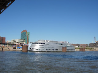
There must have been a few hundred parked barges and consider-able industry along the river through St. Louis except where the Arch is located. We also saw signs for the Riverfront Bike Route, the same one we had noticed along the Chain of Rocks Canal, and a silver casino!


Also we could see the erosion caused by high water.


One last question: How many bridges do you see?


Hoppie's Marine Service, 45 miles south in Kimmswick MO, is our location tonight. Tune in tomorrow to find out why Hoppie's is such an important marina.


Bridge Answer: 4