
Today we head for Panama City and places East! The sun was shiny when we lifted anchor at 7:45. The temperature was already 62 degrees. We are in Florida at Last. As we left Choctawahachee Bay we were traveling at 7.5 mph. There was a two mph current. We sailed right through the 15 miles of canal and out into West Bay.

The West end of the Canal had high sides and lots of trees. As we moved along it, we moved into grasses and marsh land.

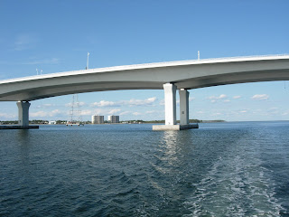
The entrance to West Bay is at the, of course, West Bay Bridge.


On the other side of the Bridge is a very small marina and interestingly enough, it has a small airplane on a hoist (right side)!

West Bay is a quarter moon-shaped body of water. We will travel 25 miles crossing it . It looks big but is relatively shallow so that our trip is from marker to marker. We are passed by a sailboat going the opposite direction and lots of small speeding motor boats. We can see high rises along the Gulf Shore.

Debbie could not get a picture of the three different groups of dolphins we saw in West Bay. They would jump around in front of the boat just far enough ahead to be out of camera range. Then they might appear right next to us but the camera wasn’t ready. Three jumped in unison out of the water just a few feet off our starboard bow. The final insult was when they appeared under our front trapeze but would not swim in front of our bow into picture range. They truly are a “playful” animal!
At the far end of the West Bay we pass under the Hathaway Bridge (50 feet clearance).
 Debbie still cannot believe all the bridges are high enough for our mast to make it under! But each time we clear the bridge.
Just beyond the bridge is the only Panama City Marina that Tom could locate that was open on Thanksgiving Day - Bay Side Marina. How we found it is a mystery. Take a look at the navigation chart. The Bridge is shown by two lines crossing the river at its narrowest part. Just above the bridge on the West (Left) side above the road number “30” is a small waterway that winds behind a large square building.


It is down this waterway with a few twists and turns back away from the river that Tom found the Bayside Marina. The owner said he was the only place pumping gas on Thanksgiving and had done it for the last four years! I don’t think staying open on Thanksgiving made a lot of money for him at least in his obscure location!

The passage way is almost the same size as our boat! Along the way residents came out of their houses and talked with us. Their directions were the only reason we found the Marina.

The Sun Harbor Marina was not open on Thanksgiving.

Instead of going out to the Gulf on the St. Andrews River, we continued East into East Bay. It isn’t as wide as West Bay but it is considerably longer and very twisted.
Debbie likes to take pictures of sailboats and here is another one we passed.

The most memorable event of the day was to find electric wires running across the East Bay. They did not look very high.

We did just clear the wires at the highest area next to one of the posts.

Remember one of the signal markers from yesterday? You might wish to get one like this one with five cormorants on top.

Now here is a boat across from where we dropped anchor that you won’t often see.

At the far end of East Bay we found a quiet spot off the marked route and enjoyed another vivid sunset and Debbie’s Birthday Dinner - Tuna Casserole, Beets and Spinach! We had traveled 60 miles in 9 hours. The last day light hour was spent with Tom suiting up and looking at the starboard rudder. It is still there and it still turns!

